Desde distintas administraciones se está intentando impulsar la creación de herramientas basadas en teledetección. Hoy en día, existe un salto importante entre los expertos en teledetección y lo que puede hacer la teledetección, y las demandas de la sociedad. Si este salto se consigue rellenar, la teledetección puede aportar elementos realmente importantes.
Para rellenar este hueco, no puedo estar más de acuerdo con lo que propone y viene haciendo el INPE desde 2004: proporcionar las imágenes de forma gratuita. Todo empieza con un programa de satélites, CBERS, China-Brazil Earth Resources Satellite, realizado entre China y Brasil. Actualmente cuentan con dos tipos de satélite en órbita, CBERS-1 y CBERS-2, que recogen imágenes de entre 260 y 20 metros de resolución espacial, y con una más que aceptable resolución espectral. Y estas imágenes las distribuyen gratuitamente (aunque yo todavía no he conseguido descargarme ninguna, pero sí he visto que tienen de España).
La siguiente presentación en formato PDF es muy interesante. Es de Gilberto Cámara, director del INPE:
http://www.dsr.inpe.br/workshopgeo/program/pdf/gilberto_camara.pdf
También incluyo un par de fotos de ejemplo: una de París, y otra de Valencia:
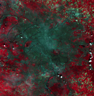
 (pulsar sobre la imagen para verla más grande) Imagen de un sector de Paris obtenida por la cámara CCD de CBERS. En la esquina superior derecha se ve el aeropuerto Charles de Gaulle, y el río Sena en la parte inferior izquierda. Al sur de esta zona está la torre Eiffel, y al norte de la torre un pequeño elemento circular tiene en su centro al arco del triunfo. La imagen fue tomada por la mañana, se puede observar la niebla.
(click on the image to make it bigger) Image of a sector of Paris obtained by the CCD camera through the CBERS recorder. In the upper right-hand corner the Charles de Gaulle airport is shown, and the Seine river in the lower left-hand corner. To the south of this area and in the other side of the river on may notice the Eiffel Tower. Northwards of the tower a small circular feature has in its center the Triumph Arc. The image was
 taken in the morning, an intense haze can be noticed.
(pulsar sobre la imagen para verla más grande)
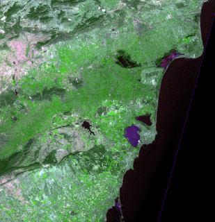
Region costera en España junto a la ciudad de Valencia. En verde claro se observa las zonas agrícolas, y en verde oscuro los bosques. Dominan los terrenos sin vegetación.
(click on the image to make it bigger)
Coastal region of Spain close to Valencia city. In light green the agricultural areas are shown, in dark green the forests, terrains without any type of vegetation are dominant.
Me gustaría añadir una reflexión: en Europa estamos utilizando GMES para cubrir el hueco mencionado anteriormente. Y a pesar de colaborar en GMES, debo decir que me parece mucho más efectiva la posición de brasileños y chinos: damos las imágenes gratuitamente, e incluso el software; en un mercado tan abierto, la teledetección se adaptará de forma natural para solucionar problemas reales de la sociedad. Tal vez en Europa nos estemos equivocando, y nuestra industria de teledetección se quede atrás en comparación con países como Brasil o China.
English version:
That's INPE's point of view; INPE stands for Instituto Nacional de Pesquisas Espaciais, the brazilian National Institute for Space Research, already known because of the SPRING software.
Many public administrations are trying to help in the process for building capacities on earth observation based products. However, nowadays there is a gap between the remote sensing experts, and the society's needs. If this gap can be filled in, the earth observation will de able to introduce very interesting elements. I completely agree with what INPE suggests and is doing since 2004: provide the satellite images for free.
Everything started with the CBERS (China-Brazil Earth Resources Satellite) satellite programme, in cooperation between China and Brazil. They currently have two kind of satellites, CBERS-1 and CBERS-2, which are collecting images with a spatial resolution that goes from 260 meters to 20 meters, and with an interesting spectral resolution too. And they are distributing these images for free (well, I still have not suceeded in downloading any, but at least I could check they also have european 20 meters ones).
The next presentation from Gilberto Camara, Director of INPE, is really interesting:
http://www.dsr.inpe.br/workshopgeo/program/pdf/gilberto_camara.pdf
I have included a couple of sample images above: Paris and Valencia.
I would like to add one thought: en Europe we are using GMES for filling the abovementioned gap in. I am collaborating with GMES, but I must say I like much more the idea of the CBERS: give the images and the tools for free; you are creating such an open market that the earth observation will adapt to the society needs in a natural way. Maybe we are making a mistake in Europe going for a company-driven approach, and maybe our earth observation industry in the future will stay behind other countries such as Brazil or China.
4 comments:
Hola Oscar y Carolina
Los felicito por su blog esta muy bueno... y La noticia de CBERS mejor aun yo soy de La Serena- Chile y era usuario de Landsat pero CBERS me parece una buena alternativa para trabajos de vegetacion
Saludos y Muchas Felicidades
Perdon
Mi nombre es David Lopez A y trabajo en la Universidad de La Serena soy profesor de Sig y Teledeteccion en Geografia y trabajo en un centro de investigacion llamado CEAZA.
atte
David Lopez A
dlopez@userena.cl
http://www.ceaza.cl
Hola a todos,
Según tengo entendido, de momento las imágenes de CBERS sólo están disponibles de forma gratuita para para nacionales brasileños. Es decir, que los que no somos brasileiros tenemos que "apoquinar".
Un saludo,
César
Hola Óscar y Carolina,
os felicito por el blog.
Una pequeña corrección: la ortoimagen es del sector costero Elx-Murcia, no de Valencia.
Suerte
Carles Sanchis
csanchis@hma.upv.es
Post a Comment